interviews

A Neighborhood Changed Forever: The Parkway East and Four Mile Run

A construction crew works on the Junction Hollow Bridge along the Penn-Lincoln Parkway (Interstate 376), known as the Parkway East. Construction began on Nov. 14, 1949, and was completed on Oct. 15, 1952. Photo courtesy of the Allegheny Conference on Community Development Photographs, 1892-1981, MSP 285, Detre Library & Archives, Senator John Heinz History Center

Carol Rizzo Hopkins, 81, lived in Four Mile Run until moving to upper Greenfield at age 14. She clearly remembers a network of trails on the hillside. “Everywhere was a path, and we walked everywhere—Schenley Park, Squirrel Hill, Beechwood Boulevard, Magee Swimming Pool. We could be anywhere in two minutes.”

“Growing up in The Run was the best time of my life,” she told me during an in-person interview in December. “It was like a little village for us.”

But the Parkway changed all that. Now, as the Pennsylvania Department of Transportation (known as PennDOT) gets started on plans to improve the Parkway East Bridge over Four Mile Run, residents face the prospect of history repeating itself.

On Dec. 1, District 5 City Council member Barb Warwick posted on Facebook that PennDOT is conducting a feasibility study to explore their options for fixing or replacing the six-span bridge.

One option the department is considering involves building a new bridge beside the existing one — similar to their plan for the Commercial Street Bridge on the other side of the Squirrel Hill Tunnels. PennDOT would destroy the existing bridge and move the new bridge in to replace it. Using this method in The Run might shorten closure time on the Parkway East, but it may displace households near the bridge.

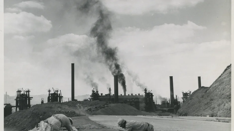
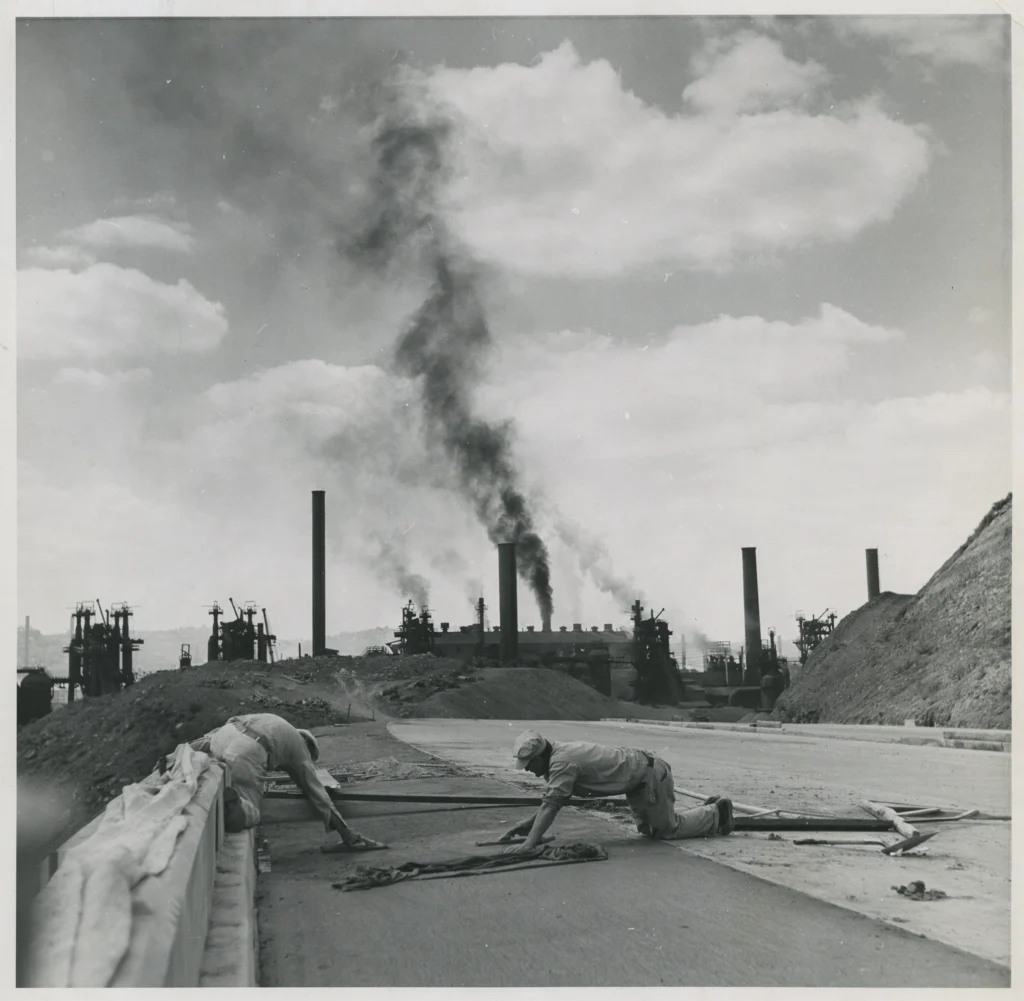
Two neighbors, Judy Gula and Ms. Hopkins, witnessed the original construction of the Parkway East bridge from 1949 to 1952.

Life in the Parkway’s shadow

Ms. Gula, 76, has lived in The Run her entire life — just like her father did. In her earliest memories, the Parkway was already under construction.

“We used to roller-skate on the Parkway before it was finished,” she recalled during an interview in December. “Kids rode their bikes and played up there. The construction workers would give us their empty pop bottles and we’d fight over who got them.”

Neighborhood children exchanged those bottles for two cents at Mary Kranyak’s candy store on Saline Street.

A construction crew works on the Junction Hollow Bridge along the Penn-Lincoln Parkway (Interstate 376), known as the Parkway East. Construction began on Nov. 14, 1949, and was completed on Oct. 15, 1952. Photo courtesy of the Allegheny Conference on Community Development Photographs, 1892-1981, MSP 285, Detre Library & Archives, Senator John Heinz History Center

Even after the Parkway opened, non-vehicular traffic continued for a time. Locals used it in ways people might find hard to imagine today.

“My dad and I would walk up to the Parkway to watch cars,” Ms. Gula said. “It was always backed up, even then.” As high school students, she and her friends would “walk the Parkway” to get to Allderdice.

Ms. Gula grew up in the shadow of the Parkway and with shadows of what it replaced. A school behind the apartment building where she lived was torn down, but she isn’t certain whether that was because of construction.

“My mother said there were steps from [The Run] to the Bridle Path [in Schenley Park] that were taken away by the Parkway,” Ms. Gula recalled.

She also remembers older relatives remarking how much quieter the neighborhood had been before the Parkway. Along with the wall of noise produced by speeding cars and trucks, the road brought other problems that continue into the present.

“We used to get all the water from the Parkway down here,” said Ms. Gula, who lives in the eastern part of The Run near the end of Saline Street. “Water used to come up to my [front] gate.”

About five years ago, crews added large rocks to slow water down in the area at the end of the street and behind the building colloquially known as “the pump house.” Ms. Gula says that has helped.

“It just destroyed us”

Ms. Hopkins’ grandmother, who lived on Naylor Street, had a small farm in the field beneath the Greenfield Bridge. The family’s seven children, including Ms. Hopkins’ father, took turns walking their cow to a nearby field to let it graze. By the time Ms. Hopkins came along, her grandmother no longer had the cow, but she still raised chickens.

The field near the pump house where the cow once grazed served as the local playground until Parkway construction began.

“They put all their equipment on our playground,” Ms. Hopkins said. She described large, hollow cylinders that looked like pipes wrapped in metal coils.

“I broke my arm,” she recalled. “I was running at nighttime, and I tripped over a coil lying on the ground. We couldn’t play there anymore.”

Of the displaced families and businesses, Ms. Hopkins remembers three in particular: the Marbella family, a market called Husky’s, and her friend Peggy. Peggy’s family lived in a stylish house with a lot of latticework.

“That’s where a pillar is now,” Ms. Hopkins said.

Ms. Hopkins and her friends and cousins from The Run still talk about the experience of having a highway carved through their idyllic neighborhood. “It affected us kids, and I’m sure the grownups,” she said. “People had cracks in their walls [from the construction] they had to fix.”

Follow this project

Councilmember Warwick encouraged people to sign up for notifications from PennDOT about the bridge project as it moves forward. She said the PennDOT team expects to have the first public meeting on its feasibility study in mid to late summer of 2024. Until then, she promised to include any new developments in the District 5 newsletter and the Facebook page for The Run.

Visit PennDOT’s project page for the feasibility study at http://tinyurl.com/Parkway-East-4-Mile-Run to see more details and instructions for getting project notifications. Visit the District 5 newsletter webpage at https://pittsburghpa.gov/council/d5-newsletters to sign up for monthly emails.

Watershed Advocacy in Hazelwood and Four Mile Run

Map of Sylvan Ave. with pins showing streams and ponds

Q&A with Annie Quinn, director of the Mon Water Project

Water issues can mean flooded streets, backed-up sewers, and even landslides. A new organization based in Greenfield has the mission of helping people with all of those. Junction Coalition spoke with Annie Quinn, director of the Mon Water Project (MWP) about water issues in The Run and Hazelwood. Ms. Quinn’s answers have been edited for length and clarity.

JC: Why did you decide to start the Mon Water Project?
AQ: I had been working for four years in watershed science. As I was attending meetings [about the Four Mile Run stormwater project] and hearing PWSA explaining the project to residents, I felt a responsibility. I wanted to help move the conversation forward. The Mon Water Project is an opportunity to serve the community in a way that helps us all with problems around water—and in Pittsburgh, we have a lot of those.

What is watershed science?
The concept of water management within a watershed—how does water move within a system? It’s an area of study that may have been called “freshwater biology” before.

How can the MWP help Hazelwood?
The [water/sewer] lines in Hazelwood are as old as the neighborhood. Hazelwood has been a neighborhood of disinvestment resulting from systemic racism, and the result of the “squeaky wheel” system: More privileged residents in other neighborhoods would call and have their pipes replaced over the years.

I want the MWP to raise voices in Hazelwood, find out about their water issues, and get resources for them. We may not know all the water issues Hazelwood residents face. I see the MWP as a chance to unite us and get good solutions for us all.

What have you done in Hazelwood so far?
Nonprofits often come into a neighborhood thinking they will be the solution to problems. I want to join existing organizations and become the neighborhood’s “Department of Water.” I’ve joined the [Hazelwood Initiative’s] environmental committee. As time goes on, I’m hoping to meet with PWSA and Grounded Strategies and build upon their relationships with residents. I’m also hoping to meet people at events and educational programs. And I would love to get out in the river on a boat so residents can see the outfall into the river. There are a lot of pathways for me to partner with everyone, and I’m looking forward to meeting residents of all the neighborhoods and working with them.

Could water issues affect the planned Sylvan Avenue Trail?
The city is going to have to be careful designing any trail through that area. The number-one issue in trail development is erosion and water damage. There are six streams that are ephemeral—which means they may not be there every day or even every season, but they are a systemic source of water. Any design will have to keep in mind that if not careful about width, ponding, and providing underground transport for water, the trail could become unusable. A pipe could direct water to flow down a steep cliff—and that could eliminate roots on the hillside and contribute to landslides. So for any design, you’d have to know how water works under and around the trail—and where is it safe for the water to go?

What have you learned so far about water issues in The Run?
When PWSA said they’re going back to the drawing board [with the stormwater project], they’re going way back… [PWSA has] a stormwater strategic plan—this is new. Before, they were doing stormwater projects more piecemeal and operating with a different metric… [In the new plan], out of all the watersheds in Pittsburgh, Four Mile Run is ranked 5 out of 19. So the good news is that PWSA plans to keep us in the top five for the city. The bad news is that this pushes the timeline [for fixing flooding in The Run]. It’s possible that Four Mile Run is looking at a delay in the promises PWSA made. The process is looking like several layers of plans, then another design and then a project—which can be very frustrating because the solutions are far in the future. We’ll have to figure out together what we do next.

How do you describe PWSA’s Four Mile Run watershed plan?
I don’t know, and I don’t think the PWSA knows either. That is the problem, and an opportunity for us to push back and get answers on that. It’s important that our next big conversation with PWSA should be answering questions like, how much additional flow will the project capture? What level of storm is that? Have you evaluated what level of service has allowed this type of flooding in the past? What level of service does this project get up to? There is an opportunity through modeling to predict how the system acts before, during, and after the project. At the MWP, we can analyze data. As a nonprofit, we can use PWSA data and study it from different angles to get some good answers and partner with PWSA to get grants. I’m thinking about how we can take our advocacy to the next level.

How does removal of the work in Junction Hollow affect flood control?
The green infrastructure that was proposed in the park…was designed with underdrains so some water goes to groundwater, but a lot is stored and released slowly. [PWSA] said at the [latest] meeting that the new direction [removing the green infrastructure piece] was managing the same amount of water. Slow release would allow them to account for that—the size of the pipes is accounting for holding water back and releasing it slowly… How can we do more storage and slow releasing above ground? How can we avoid feeding a stream into a pipe? The original plan still included water going back into a pipe.

How can the MWP help increase the plan’s effectiveness?
The MWP can be more nimble, flexible, and fluid—like water!— in that we are not a government agency with bureaucracy, with politics. We are a grassroots community organization that can apply for grants the city can’t apply for. Nonprofits often can handle problems quicker, or at least bring a distinct perspective. A unified voice for people throughout the watershed. We’re allowed to dream big and do big, innovative projects.

How can people get involved?
I am a fiscally sponsored nonprofit of another nonprofit—New Sun Rising. My first job is to get a list of leaders to help decide where the MWP goes next. If you are interested, you don’t have to be a professional—just someone in the community who wants to be actively engaged in a leadership role.

Another way to get involved is to sign up for the newsletter to stay up to date as we grow. Right now, that looks quiet. I want to meet the people who are already here.

Visit Monwaterproject.org or email annie@monwaterproject.org for more information.

Notes

About the image: This map shows six springs and ponding along the portion of Sylvan Avenue closed by the city due to landslides. Sylvan Avenue was part of the now-canceled Mon-Oakland Connector shuttle road route between Oakland universities and the Hazelwood Green development. A bike and pedestrian trail has been proposed along the same route. Courtesy of the Mon Water Project

This interview originally appeared in The Homepage.