These matters are not easily addressed. Yet when attendees asked about them, DOMI project manager Michael Panzitta responded, “That’s a good point” or, “We’re looking into that.” How has DOMI not heard the same resident concerns since 2018, when the Sylvan Avenue Trail was first proposed as phase 2 of the Mon-Oakland Connector shuttle road between Oakland university campuses and the Hazelwood Green development?
This chart comes from a 2020 memorandum leaked to Junction Coalition in which former DOMI director Karina Ricks addressed Pittsburgh City Council and for the first time named specific components and costs of the MOC project.
Community input
Discussion of this trail began with the Mon-Oakland Connector (MOC) instead of the communities in its path. Public meetings about development and infrastructure projects should focus on dialogue, not checking the “community engagement” box in a rush toward predetermined outcomes. Since 2022, Junction Coalition has been calling on the city to adopt our guidelines for public engagement, including announcing meetings at least 14 days in advance and posting the meeting slides with the announcement.
The design presented bore a striking resemblance to the MOC. Controversy plagued the plan partly because of dishonest tactics used to force it on affected communities. Opacity was and is its hallmark: inadequate community outreach for public meetings, evasive answers and an unwillingness to clearly define the scope of and intentions behind each phase of the project.
For example, while holding public meetings about the shuttle road in 2018, DOMI hid its grant applications for work on the Sylvan Avenue portion of the road.
Before informing affected communities about the MOC through a Pittsburgh Post-Gazette article, former mayor Bill Peduto’s administration filed a fraudulent grant application for the project for $3 million and then tried to cover it up, violated the Pennsylvania Sunshine Act, and repeatedly violated PA’s Right to Know law throughout the years-long process of trying to bully the plan through.
The recent Sylvan Avenue Trail meeting presentation did not even include a budget slide. How much money has the Sylvan Avenue Trail received as part of the MOC? How much is budgeted to address the major environmental and safety issues, like an abandoned mine under part of the project area?
Slides showed an unrealistic rendering of the trail with mature plantings to obscure removal of existing trees and gentle slopes instead of cliffs.
Some residents who arrived early said they were told city officials were holding a separate, closed-door meeting with PennDOT before the public meeting.
And according to Mr. Panzitta and Pittsburgh Neighborhood Services infrastructure engagement specialist Jan Raether, this was to be the only public meeting about the Sylvan Avenue Trail.
Unfortunately, this territory is all too familiar. It is obvious to us and others in Greenfield and Hazelwood that, although Mayor Ed Gainey canceled the MOC, DOMI has continued to plan out a buildout of the project.
What’s not missing from the Sylvan Avenue Trail project is red flags that point to a road paved with bad intentions.
Some residents of Greenfield and Hazelwood have organized meetings to discuss the project and reach consensus on an alternative proposal. Reach out to Junction Coalition at junctioncoalition@gmail.com if you are interested in getting involved.
On June 21, Pittsburgh City Council passed Resolution 1619-2023, which formally recognizes 28 acres between Panther Hollow and The Run—known as Junction Hollow—as part of Schenley Park. The same day, they passed an ordinance (1620-2023) that got less attention at the time but could help any Pittsburgh resident who wants to have their say in the future of a city park.
District 5 councilor Barb Warwick introduced both pieces of legislation, stressing the importance of parks. In her resolution, she wrote that Junction Hollow provides recreational space and is vital for green stormwater management. She told the Pittsburgh Tribune-Review on June 7 that Junction Hollow “has been part of the park in layman’s terms for a long time, but it’s not officially designated as a park.”
Now, it enjoys the same protections as the rest of Schenley Park.
Councilor Warwick said during a July 7 phone call that her office is working to introduce related measures over the next few months. Their common goal is to prevent development-oriented projects like the now-defunct Mon-Oakland Connector (MOC) from being forced on communities that do not want them.
Lessons Learned from the Battle of Four Mile Run
“Throughout the MOC fight, the city was trying to turn a park into a shuttle road,” Councilor Warwick said. “The city’s argument was that it used to be a road; it didn’t matter that it’s a park now. [The resolution that passed] is just to make it clear that this is a park now.”
Residents in MOC-affected communities didn’t know that Pittsburgh’s Home Rule charter gives them the right to petition the city for a public hearing on what Ordinance 1620-2023 calls “the change of use of a City Park or Greenway.” And they could have bolstered their case against allowing the MOC in Schenley Park by citing a state law called the Donated or Dedicated Property Act. It says land donated or dedicated as a park cannot be taken out of the public trust to serve other purposes. The ordinance requires the city to tell petitioners that the Donated or Dedicated Property Act exists, and that they have a right to use it to defend public land.
Councilor Warwick said her office is working on legislation to introduce in the fall setting rules for development in city parks. Without changing zoning laws, she wants to focus development only on the public’s enjoyment of the parks. For example, the MOC was a roadway or thoroughfare intended to connect two neighborhoods, not promote use of the park itself.
At the time of our interview, Councilor Warwick was planning to introduce legislation on July 18 that would change the city’s process of applying for certain grants. When a city department decides to apply for a grant worth more than $250,000 or to fund a project that is not already in the capital budget, they would have to notify City Council before applying.
“It doesn’t give us a vote, but earlier on in the process, we have an opportunity to ask questions,” Councilor Warwick explained. “If we don’t support the project and they apply for the grant anyway, when the grant does come to a vote at the end there is a record of these issues.”
The point of involving City Council earlier, she said, is “ensuring that when the city is pursuing a grant for a project, it is one the community wants or has identified as a need. That’s all we should ever be doing, but the reality is it hasn’t been. Big, visionary things are fine, but we need to be focusing on the communities’ day-to-day needs.”
Shaping the Future of Sylvan Avenue Trail
Councilor Warwick saw firsthand how communities can be left out of deciding which projects to fund with grants. During a series of public meetings about the MOC in 2018-2019, the Department of Mobility and Infrastructure, known as DOMI, applied for a grant to build the Sylvan Avenue trail (part of the MOC route) without informing the public. After receiving the grant, they pushed the project through by raising the specter of leaving money on the proverbial table.
“If they were doing this now and notified me, I would have asked, ‘Why are we applying for this grant when there are so many other things that need to be done for Hazelwood?’” Councilor Warwick said.
But since the trail project is moving forward, she added that she intends to make the best of it. “We’re trying to put money toward creating a plan for the Sylvan Avenue trail instead of it just being a DOMI bike trail. We want to include a plan for the larger space because it is now a park.”
The trail is part of the Hazelwood Greenway, which was designated a city park in December 2021. That means it has the same current and future protections as Schenley Park.
“It’s going to take years, but whatever the design is for that trail, I want it to include what that park could look like 5 to 10 years from now with investment,” Councilor Warwick said. “It’s for the community, not just commuters passing through.”
Q&A with Annie Quinn, director of the Mon Water Project
Water issues can mean flooded streets, backed-up sewers, and even landslides. A new organization based in Greenfield has the mission of helping people with all of those. Junction Coalition spoke with Annie Quinn, director of the Mon Water Project (MWP) about water issues in The Run and Hazelwood. Ms. Quinn’s answers have been edited for length and clarity.
JC:Why did you decide to start the Mon Water Project? AQ: I had been working for four years in watershed science. As I was attending meetings [about the Four Mile Run stormwater project] and hearing PWSA explaining the project to residents, I felt a responsibility. I wanted to help move the conversation forward. The Mon Water Project is an opportunity to serve the community in a way that helps us all with problems around water—and in Pittsburgh, we have a lot of those.
What is watershed science? The concept of water management within a watershed—how does water move within a system? It’s an area of study that may have been called “freshwater biology” before.
How can the MWP help Hazelwood? The [water/sewer] lines in Hazelwood are as old as the neighborhood. Hazelwood has been a neighborhood of disinvestment resulting from systemic racism, and the result of the “squeaky wheel” system: More privileged residents in other neighborhoods would call and have their pipes replaced over the years.
I want the MWP to raise voices in Hazelwood, find out about their water issues, and get resources for them. We may not know all the water issues Hazelwood residents face. I see the MWP as a chance to unite us and get good solutions for us all.
What have you done in Hazelwood so far? Nonprofits often come into a neighborhood thinking they will be the solution to problems. I want to join existing organizations and become the neighborhood’s “Department of Water.” I’ve joined the [Hazelwood Initiative’s] environmental committee. As time goes on, I’m hoping to meet with PWSA and Grounded Strategies and build upon their relationships with residents. I’m also hoping to meet people at events and educational programs. And I would love to get out in the river on a boat so residents can see the outfall into the river. There are a lot of pathways for me to partner with everyone, and I’m looking forward to meeting residents of all the neighborhoods and working with them.
Could water issues affect the planned Sylvan Avenue Trail? The city is going to have to be careful designing any trail through that area. The number-one issue in trail development is erosion and water damage. There are six streams that are ephemeral—which means they may not be there every day or even every season, but they are a systemic source of water. Any design will have to keep in mind that if not careful about width, ponding, and providing underground transport for water, the trail could become unusable. A pipe could direct water to flow down a steep cliff—and that could eliminate roots on the hillside and contribute to landslides. So for any design, you’d have to know how water works under and around the trail—and where is it safe for the water to go?
What have you learned so far about water issues in The Run? When PWSA said they’re going back to the drawing board [with the stormwater project], they’re going way back… [PWSA has] a stormwater strategic plan—this is new. Before, they were doing stormwater projects more piecemeal and operating with a different metric… [In the new plan], out of all the watersheds in Pittsburgh, Four Mile Run is ranked 5 out of 19. So the good news is that PWSA plans to keep us in the top five for the city. The bad news is that this pushes the timeline [for fixing flooding in The Run]. It’s possible that Four Mile Run is looking at a delay in the promises PWSA made. The process is looking like several layers of plans, then another design and then a project—which can be very frustrating because the solutions are far in the future. We’ll have to figure out together what we do next.
How do you describe PWSA’s Four Mile Run watershed plan? I don’t know, and I don’t think the PWSA knows either. That is the problem, and an opportunity for us to push back and get answers on that. It’s important that our next big conversation with PWSA should be answering questions like, how much additional flow will the project capture? What level of storm is that? Have you evaluated what level of service has allowed this type of flooding in the past? What level of service does this project get up to? There is an opportunity through modeling to predict how the system acts before, during, and after the project. At the MWP, we can analyze data. As a nonprofit, we can use PWSA data and study it from different angles to get some good answers and partner with PWSA to get grants. I’m thinking about how we can take our advocacy to the next level.
How does removal of the work in Junction Hollow affect flood control? The green infrastructure that was proposed in the park…was designed with underdrains so some water goes to groundwater, but a lot is stored and released slowly. [PWSA] said at the [latest] meeting that the new direction [removing the green infrastructure piece] was managing the same amount of water. Slow release would allow them to account for that—the size of the pipes is accounting for holding water back and releasing it slowly… How can we do more storage and slow releasing above ground? How can we avoid feeding a stream into a pipe? The original plan still included water going back into a pipe.
How can the MWP help increase the plan’s effectiveness? The MWP can be more nimble, flexible, and fluid—like water!— in that we are not a government agency with bureaucracy, with politics. We are a grassroots community organization that can apply for grants the city can’t apply for. Nonprofits often can handle problems quicker, or at least bring a distinct perspective. A unified voice for people throughout the watershed. We’re allowed to dream big and do big, innovative projects.
How can people get involved? I am a fiscally sponsored nonprofit of another nonprofit—New Sun Rising. My first job is to get a list of leaders to help decide where the MWP goes next. If you are interested, you don’t have to be a professional—just someone in the community who wants to be actively engaged in a leadership role.
Another way to get involved is to sign up for the newsletter to stay up to date as we grow. Right now, that looks quiet. I want to meet the people who are already here.
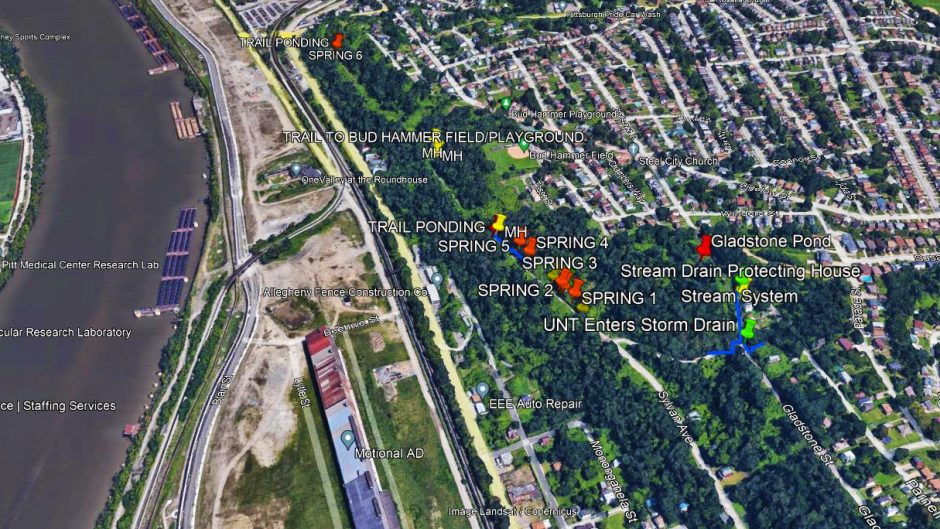
About the image: This map shows six springs and ponding along the portion of Sylvan Avenue closed by the city due to landslides. Sylvan Avenue was part of the now-canceled Mon-Oakland Connector shuttle road route between Oakland universities and the Hazelwood Green development. A bike and pedestrian trail has been proposed along the same route. Courtesy of the Mon Water Project
This interview originally appeared in The Homepage.
Greenfield and Hazelwood residents made progress toward safety improvements in their neighborhoods last year—but it wasn’t easy. As 2022 drew to a close, yet another accident on Greenfield Avenue highlighted the need to prioritize fixing dangerous traffic conditions in the area.
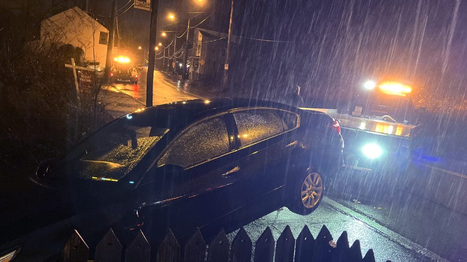
Uneven sidewalk prevents a New Year’s Eve tragedy
Around 7 p.m. on December 31, a westbound car jumped the curb in the 200 block of Greenfield Avenue. It balanced atop a steep hill and may have barreled toward houses in The Run, but its underside caught on the sidewalk’s edge. As tow truck operators on the scene struggled to remove the vehicle, police officers alerted affected residents.
According to Pittsburgh’s Department of Mobility and Infrastructure (DOMI), Greenfield Avenue qualifies for the Neighborhood Traffic Calming program, but will not receive funds for construction this year. Despite increasingly frequent and severe accidents along the 200-300 block of Greenfield Avenue, nothing will be done until at least 2026, after the anticipated replacement of Swinburne Bridge. At a July 14 meeting about that project, project manager Zachary Workman said, “It’s definitely something that’s on DOMI’s radar for improvements in the future but it’s in the long-range plan as resources become available.”
When Mayor Ed Gainey held a community meeting in Greenfield last month on January 14, residents identified conditions all along Greenfield Avenue as a top concern.
DOMI promises traffic calming on Hazelwood Avenue
Newly elected District 5 City Councilperson Barb Warwick brokered a major milestone in traffic calming along Hazelwood Avenue. At a December 14 City Council meeting, DOMI director Kim Lucas committed to completing “spot improvements” on the upper part of this narrow, busy street in 2023.
In addition, Councilperson Warwick said during a January 6 phone call, “[DOMI] will do comprehensive traffic calming along the whole street long term.”
DOMI’s promise of larger-scale improvements shows they recognize hazards that have plagued residents and travelers along Hazelwood Avenue for decades. These include constant speeding, faded pedestrian crosswalks, and oversize trucks using the street as a shortcut.
However, DOMI only agreed to begin the work now in exchange for support of the Sylvan Avenue repaving project.
Adjustments to the Sylvan Avenue Trail project
This relatively quiet side street is slated for raised pedestrian crosswalks, repaving, and new sidewalks between Hazelwood Avenue and Home Rule Street. When DOMI introduced the project at an April 26 public meeting, attendees expressed concerns about its potential effects on Sylvan Avenue residents and its limited scope—especially considering neglected infrastructure and dangerous traffic patterns in the same area.
DOMI responded to these concerns by adding a pedestrian refuge island on Hazelwood Avenue at the Sylvan Avenue intersection, DOMI project manager Michael Panzitta said at a second public meeting on November 30. In addition, DOMI changed its plans for street markings to show bikes and cars are sharing the road. Instead of advisory bike lanes, this entire stretch of Sylvan Avenue will have a Neighborway design that may be more familiar to local drivers.
The project is part of a future pedestrian/cyclist trail along the route of the rejectedMon-Oakland Connector (MOC) shuttle road. Landslides and water runoff issues complicate work on the next leg of Sylvan Avenue, which will connect Hazelwood Avenue to another busy, dangerous street: Greenfield Avenue.
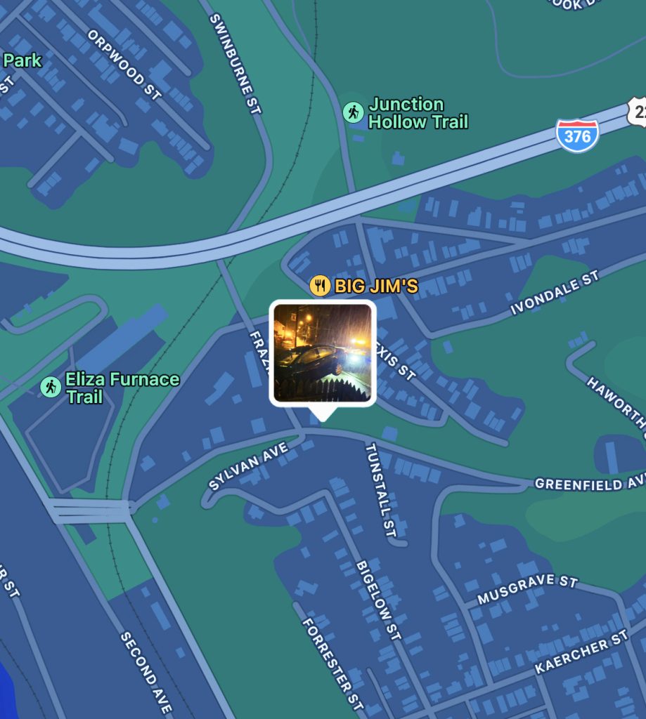
A map of the area around Greenfield Avenue shows the location of the New Year’s Eve accident. Image by Ray Gerard
Irvine Street sidewalks completed
Thanks to state and federal funding, an existing connection between Hazelwood and Greenfield avenues got long-overdue upgrades last summer. Replacement of Irvine Street’s disintegrated sidewalks wrapped up in mid-November, City of Pittsburgh press officer Emily Bourne confirmed in a January 17 email. Soon after, crews finished the signs and signal work.
“Several minor, weather-dependent, pavement markings are outstanding,” Ms. Bourne added. “These are anticipated to be completed in the spring.”
A terrible loss draws attention to Johnston Avenue
After a 6-year-old Glen Hazel boy was hit and killed by a car on July 26, neighbors pointed out that they had been requesting traffic-calming measures such as speed humps for years.
Mayor Gainey held a community meeting on October 5 and later committed to safety improvements along Johnston Avenue. Crews finished some minor work, such as street markings, before winter. No date was given for speed humps and other uncompleted items. But municipal traffic engineer Mike Maloch said during the community meeting, “When weather breaks in 2023, [speed humps] will be implemented quickly.”
Working toward safer streets in 2023
It should not take a tragedy as horrible as the death of a child to get simple, even temporary, traffic-calming measures—especially in the midst of major construction projects improving access to the Hazelwood Green development.
In 2019, surrounding communities created the Our Money, Our Solutions plan to identify their needs. The plan prioritized traffic calming on both Greenfield and Hazelwood avenues, as well as safer pedestrian crossings on Second Avenue.
As Hazelwood and Greenfield residents continue advocating for traffic safety measures, the Gainey administration seems to be listening. Deputy mayor Jake Pawlak told attendees at the Greenfield community meeting that Pittsburgh’s 2023 budget includes increased funds for traffic calming, which is in high demand all over the city. This year should bring clarity on if and how the city will make these key improvements in 15207.
Pittsburgh’s Department of Mobility and Infrastructure (DOMI) held a public meeting on July 14 about the Swinburne Bridge project. Mayor Gainey’s neighborhood services manager, Rebekkah Ranallo, debuted as a co-facilitator.
Ms. Ranallo seemed genuinely excited to learn that about 20 residents of Four Mile Run (“The Run”) and their friends had gathered at their local pub to participate as a group in the Zoom-only meeting. “I think it’s great that folks are getting together for civic engagement opportunities like this,” she said.
During the Q&A session, attendees brought up a list of community demands (listed below) for a transparent public process. Ms. Ranallo assured them on behalf of DOMI and the mayor’s office, “We want to let you know that improving the way all of our departments do community engagement with our residents is a top priority.”
As the City of Pittsburgh begins “engaging” communities about this project, it’s important to understand why getting involved is a matter of survival for affected residents—and how they lost trust in local institutions tasked with serving the public interest.
In August 2015, Run residents learned of Mon-Oakland Connector (MOC) shuttle plans from a Pittsburgh Post-Gazette article touting an already-submitted grant application that turned out to be fraudulent. DOMI, created in 2017, initially claimed they were pushing the restart button on the MOC concept. But the restart got off to a bad start when DOMI organized a January 2018 public meeting to “share the potential alternative routes” for the MOC. Attendees reported that the exercise seemed designed to herd them toward a conclusion that only the Schenley Park route could work.
Over ensuing years, DOMI continued pushing the MOC on affected communities in a dishonest and non-transparent way. These are just a few examples:
On April 13, 2018, DOMI filed for a $1 million grant for work on the Sylvan Avenue trail, part of the MOC route, to make the trail suitable for MOC shuttles. At a public meeting the following month on May 22, DOMI did not mention the grant at all. When the grant was approved in July 2018 by the Southwestern Pennsylvania Commission, DOMI still did not inform affected residents. Asked about the grant and why DOMI kept it secret from residents, former DOMI director Karina Ricks said, “Well… we could have handled that better” and “It’s not possible for there to be some conspiracy—we’re just not competent enough for that.”
In August 2020, residents on Acorn Street near the Swinburne Bridge received a letter from DOMI and AWK Consulting Engineers citing eminent domain. When asked about this at the October 2020 MOC meeting, Ms. Ricks responded, “It is a letter written by a lawyer and, unfortunately, they do reference the right of eminent domain. The City has absolutely no intention to take properties [as part of the bridge construction]. There is a possibility there might be some slivers that will be needed to create new footings for the bridge.”
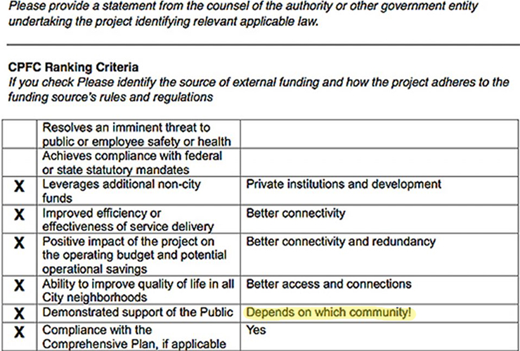
Residents obtained a 2018 request from DOMI to Pittsburgh’s Office of Management and Budget for funding. That document is mostly blank, but DOMI was nonetheless given $9 million of taxpayer funds. One section of the document DOMI did fill out was the section reading: Please identify the source of external funding and how the project adheres to the funding source’s rules and regulations. “Demonstrated support of the public” was a checklist item within that section. DOMI checked off this item and commented: Depends on which community!
A section of the City Budget form shows DOMI’s response to whether the project has community support.
Additional information received through resident-filed Right-to-Know requests, sources in city government, and expert independent consultations revealed the true “vision” behind the MOC and the nature of Hazelwood Green’s relationship to surrounding communities. Private interests have a long-term plan that calls for erasing The Run off the map so universities can expand from Oakland campuses to Hazelwood Green. And it includes using eminent domain to acquire resident homes and business.
A 2009 study from the Remaking Cities Institute of Carnegie Mellon University (CMU), Remaking Hazelwood, makes this intention clear:
“The urban design recommendations proposed in this document extend beyond the boundary of the ALMONO site. The end of Four Mile Run valley, the hillside and Second Avenue are all critical to the overall framework. Some of these areas are publicly-held; others are privately-owned. A map is in the section Development Constraints. The support of the City of Pittsburgh and the Urban Redevelopment Authority (URA) will be critical to the success of our vision. The ALMONO, LP could try to purchase these sites. Failing that, the URA can support the project by purchasing those properties that are within the scope of the recommendations and making them available for redevelopment in accordance with the proposed strategy.”
Unfortunately for existing communities seen by the authors of this report as “development constraints,” there is no evidence that underlying goals have changed for development in the area.
Public meetings about these projects have not shown improvement, either. DOMI originally scheduled the Swinburne Bridge meeting for June 16, but residents pushed back after finding out only 10 days in advance. The extent of DOMI’s outreach for that original meeting was a letter sent to a few residents, which those residents received on June 6. The rest of the community learned of the meeting through their neighbors who received the letter.
During a month-long lead-up to the rescheduled meeting, several residents asked DOMI to make the presentation (which they presumably would have prepared for the June meeting) available so the public would have time to review it in advance. None of the residents received a direct response from DOMI. About four hours before the start of the July 14 meeting, project manager Zachary Workman posted a statement in the Q&A section of the project’s Engage PGH webpage that DOMI would not honor the request.
Community demands shaped by experience
Residents have learned from years of MOC public meetings designed to check a “community engagement” box while minimizing the community’s effect on predetermined outcomes. The whole time, they were communicating ideas for better public engagement to DOMI—but DOMI ignored them. Residents have called for the following:
All meetings must be posted with a minimum of 14 days’ notice to allow working people to arrange their busy lives to attend and have their voices heard. The meeting information must be widely advertised on social media, sent to email lists, and communicated by any means necessary to community members who lack internet access.
The meeting presentation must be posted at the same time the meeting is announced. The public must be afforded sufficient time to review and understand the information being presented so they can come to the meeting prepared with questions. If you do not yet have the presentation ready, then you should postpone the meeting to give people a chance to review the presentation after you have posted it.
All meetings must include a Q&A session where every attendee is able to hear all questions asked and all answers given. The Q&A session itself should be expected to last at least an hour, if not two hours. All answers to questions should be thorough and truthful, with a clear plan for following up on information DOMI doesn’t have. The Q&A session must not be curtailed because of time constraints, especially if the presentation has taken up more than half the allotted time for the meeting. There is no reason the presentation should require so much time, especially since the public will have already had a chance to review it. Dialogue with the community should be the main focus of all meetings.
Meetings must offer an in-person option so that no community members are excluded.
Meetings with a virtual component must provide space for at least 300 virtual attendees so that no one is unable to access the meeting at any time.
After the meeting, a recording of the Zoom meeting and the chat transcript must be made available on the Engage PGH website.
Ms. Ranallo said at the July 14 meeting, “While I can’t speak to each item on your list of demands, we do want to build trust with you … We have a new administration, we have new leadership at DOMI, and we ask that you give us a chance to try to earn that trust.”
The community’s demands were compiled as a road map the city can follow to do exactly that.
Crumbling city steps. Disintegrating sidewalks. Bridges neglected for decades. As the project formerly known as the Mon-Oakland Connector (MOC) moves forward without Almono Partners’ shuttles, residents of MOC-affected communities are asking why the project still takes precedence over fixing dangerous conditions in the same area.
Along Hazelwood and Greenfield avenues, the skewed priorities have become impossible to ignore after two serious car accidents in the past two months.
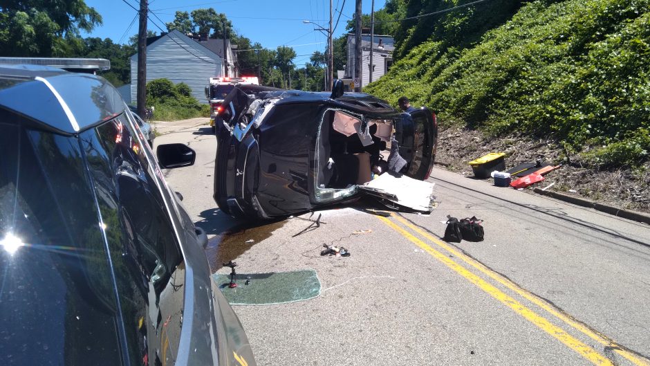
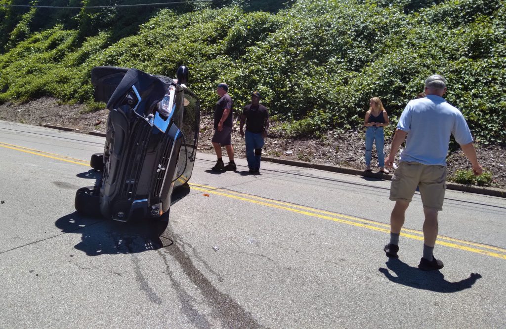
Flipped car on Greenfield Avenue
At approximately 1:20 p.m. on June 23, Greenfield Avenue resident Will Smith heard a loud noise. He told us during a July 5 phone conversation that when he looked out his front window, he saw a car that had apparently flipped over and was resting on its side in the middle of the street.
Mr. Smith rushed outside with his phone to document the accident’s aftermath. The car’s roof was crushed. A man and two women had stopped and were checking on the trapped driver. Police arrived on the scene and closed the block to traffic. Within 15 minutes, firefighters arrived to rescue the man from his car using Jaws of Life. The driver was unconscious when placed on a stretcher and driven away by ambulance.
Photo courtesy of Will Smith
A witness driving behind the car said she saw another car cross the center line as it traveled east up Greenfield Avenue, causing the westbound driver to swerve and clip the side of a parked car before flipping over.
At the scene of the June 23, 2022 accident on Greenfield Avenue. Video courtesy of Will Smith.
Mr. Smith commented on the accident, “This was inevitable.” He described speeding on the narrow lower portion of Greenfield Avenue as “ridiculous” and noted, “Every resident’s car parked on the street was just ticketed a few weeks ago.”
Mr. Smith and his neighbors received $114 citations in the early hours of May 9 for having their wheels on the curb. Parking this way is common on Greenfield Avenue and other narrow streets where residents try to protect their vehicles from speeding drivers. One recent hit-and-run totaled the parked car of a resident who is also a city employee. Residents’ only available parking is on the downhill side of the street. They have to cross through swiftly-moving traffic to reach their houses.
“The city needs to do something to make drivers slow down and pay attention,” Mr. Smith said.
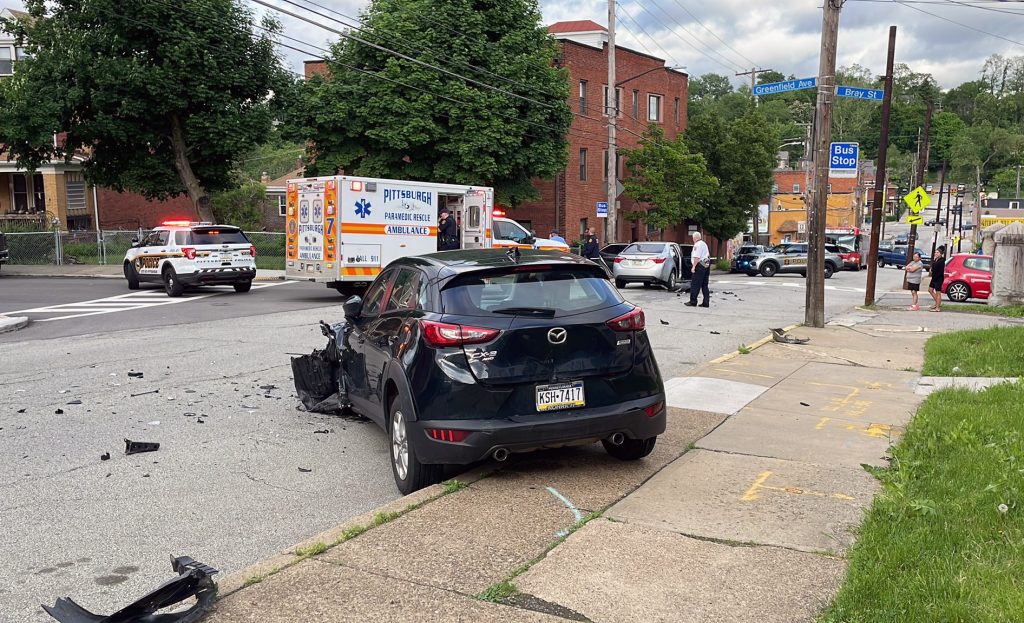
Multi-vehicle crash on Hazelwood Avenue
Residents along Hazelwood Avenue face similar dangers. On May 22, Kevin Dole witnessed the immediate aftermath of an accident at the corner of Greenfield and Hazelwood avenues near his home. When we spoke by phone on June 30, he said four or five vehicles were involved—including his neighbor’s parked car, which was totaled. An ambulance transported one person away from the scene.
Photo courtesy of Greenfield Livable Streets
Mr. Dole said speeding is a constant hazard on Hazelwood Avenue, a narrow two-lane road with parking on both sides. He guessed the average speeder travels 45-50 mph in the 25 mph zone and “would not be able to stop in time if someone stepped out.”
“It’s common to see detached side mirrors on the ground and people parked a little up on the sidewalk,” Mr. Dole said. In addition, he described faded pedestrian crosswalks and oversized trucks using Hazelwood Avenue as a shortcut to Hazelwood Green or other construction projects.
“There is no infrastructure to encourage people to slow down and no enforcement of the speed limit,” he added.
Although it was the first accident Mr. Dole saw, being a relative newcomer to the neighborhood, he has personally witnessed “many close calls” and heard from neighbors about other crashes.
One neighbor, Abby Zupancic, suffered a broken neck and other severe injuries in October 2016 when a vehicle hit him in front of his house. Mr. Zupancic told us what happened when we spoke by phone on July 8.
“Me and my wife and kids came home from shopping. My wife and son went in the house, and my daughter and I were behind them. I told my daughter, ‘Hang on a second, sweetie. I forgot to put the [side-view] mirror in.’ I went back out to the car, put in the mirror.” Mr. Zupancic was walking in front of his car when the vehicle plowed into him. He flipped in the air and bounced off the vehicle, then the ground.
Mr. Zupancic underwent emergency surgery and a grueling recovery process. “It took about a year to get fully functional,” he recalled. Although he still deals with chronic pain, he was eventually able to return to his job as a highway construction worker.
Mr. Zupancic, who has lived on Hazelwood Avenue for 18 years, said he sees dangerous speeding on a daily basis. He has witnessed two accidents in which a car flipped over—“which tells you how fast they had to be going.”
As for oversized trucks, Mr. Zupancic pointed out that a sign at the intersection of Greenfield and Hazelwood avenues clearly shows with an arrow that the truck route is in the opposite direction from the residential part of Hazelwood Avenue. But truck drivers ignore the posted route, not only worsening dangerous conditions but using “jake brakes” at all hours.
“It’s loud, it’s obnoxious, it rattles your windows,” Mr. Zupancic said. “This is a residential street, not a highway.”
Conditions are no better at the other end of the street near Second Avenue, where Reverend Michael Murray has lived for 26 years. During a July 4 phone call, Rev. Murray said over the past few years he’s noticed an increase in speeding and oversized trucks “beyond construction vehicles—trucks with great big iron rolls on the back, trucks carrying cars.”
“Some of the trucks are so huge you feel vibrations when they’re passing the house,” he added. He has lost three mirrors from side-swipes of his parked vehicle.
Rev. Murray is concerned that the problems will get even worse once construction on the nearby Hazelwood Green development is in full swing.
But residents on both streets said that years of calls to 311 and direct appeals to city officials have changed nothing.
Qualified, but not prioritized for traffic calming
Some members of Junction Coalition participate in the Greenfield Community Association’s (GCA’s) Development and Transportation Committee. The committee was copied—along with District 5 city Councilman Corey O’Connor’s chief of staff Matt Singer—on email correspondence between Greenfield resident and GCA board member Catherine Adams and representatives of Pittsburgh’s Department of Mobility and Infrastructure (DOMI).
A May 5 email from Cortney Patterson of the DOMI Traffic Bureau referenced an application for the Neighborhood Traffic Calming program. “Your street does meet the Neighborhood Traffic Calming requirements, however, this project did not rank high enough to be funded for construction this year.”
Ms. Adams responded on May 13, thanking DOMI for the information and clarifying that two separate requests were submitted—one for Hazelwood Avenue from Murray Avenue to Bigelow Street and a second, independent request for a study of Greenfield Avenue from Lydia Street to the Saline/Second/Irvine intersection.
She asked for more details on the studies conducted on both streets and what the results mean. Additionally, Ms. Adams wanted to know where Hazelwood and Greenfield avenues fall on the list of priorities so residents can anticipate when projects might be started and what to expect.
Ms. Adams sent a follow-up email on May 30, noting the accident on Hazelwood Avenue. She followed up again on June 26, but has not received a response from DOMI.
Major construction supporting Hazelwood Green
Several projects are planned or under way in the area—in some cases a few dozen feet from where accidents took place on Hazelwood and Greenfield avenues. But these investments seem designed to continue the former MOC project and improve access to the Hazelwood Green development.
Widening Greenfield Avenue at the Irvine Street/Second Avenue intersection. One block west of the June 23 accident described by Mr. Smith, construction is in progress to create a dedicated left-turn lane onto Irvine Street for traffic heading toward Hazelwood Green (as stated in the Pennsylvania Department of Transportation’s September 26, 2018, meeting presentation called “Hazelwood Green Phase I Mitigation”). To make room for the additional lane, crews are narrowing the sidewalk at this busy intersection.
Reconfiguring the residential portion of Sylvan Avenue. At DOMI’s April 26 meeting about the Sylvan Avenue Multimodal Project, residents expressed concerns that planned improvements along the quiet street fail to address problems with nearby infrastructure and dangerous traffic patterns at both ends of the finished trail. The Sylvan Avenue trail, part of the proposed MOC shuttle route, connects Greenfield and Hazelwood avenues.
There is no infrastructure to encourage people to slow down and no enforcement of the speed limit.
Kevin Dole
Replacing Swinburne Bridge.The 107-year-old bridge has long been in poor condition. In a 2018 MOC public meeting, DOMI proposed using the bridge as part of the MOC route. During an October 2020 meeting, former DOMI director Karina Ricks assured affected residents that “the city has absolutely no intention to take properties [as part of the bridge construction].” But in the next breath, she added, “There is a possibility there might be some slivers that will be needed to create new footings for the bridge.” As of July 11, DOMI had not posted a presentation for residents to review before the July 14 meeting about the Swinburne Bridge project despite repeated requests.
Safety of residents should come first
“Residents of Hazelwood and Greenfield have been crystal clear about the kinds of solutions that would make their streets safer and more accessible,” said Dan Yablonsky, director of communications and development at Pittsburghers for Public Transit (PPT).
PPT worked with residents and community groups throughout MOC-affected neighborhoods to create Our Money, Our Solutions (OMOS), an alternative plan listing needed improvements that cost less than the MOC’s projected $23 million budget. These include traffic-calming measures on Greenfield and Hazelwood avenues.
“Infrastructure like speed tables to slow down car traffic, better sidewalks, more lighting, more benches, and better bus stops would all help improve access for all,” Mr. Yablonsky wrote in a July 11 email. “But when the rubber hits the road, we see time and time again that the city ends up spending money on infrastructure projects to benefit the developers at Hazelwood Green instead of the people who have called these neighborhoods home.”
“It doesn’t have to be this way,” he added. “Residents have done the work to make it clear what investments benefit the community. It’s up to the city now to follow their lead.”
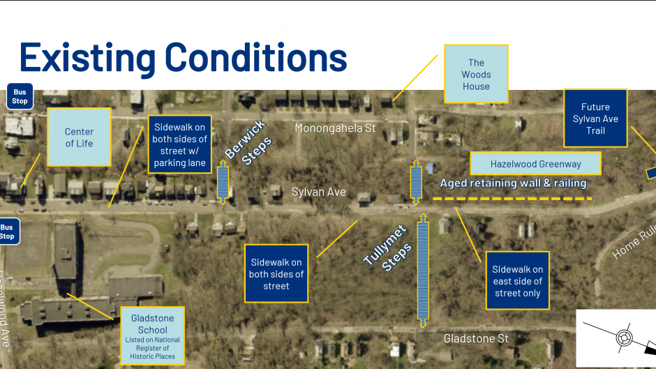
On April 26, Pittsburgh’s Department of Mobility and Infrastructure (DOMI) hosted a meeting via Microsoft Teams to kick off public engagement on its Sylvan Avenue Multimodal project, presenting early plans and fielding questions from community members.
Many of those questions revealed concerns about the project’s limited scope, its priority level and timing, and its potential effects on residents along Sylvan Avenue.
A project within a project
The Sylvan Avenue Multimodal project is one part of a pedestrian/cyclist trail that replaces—but follows the route of—the controversial Mon-Oakland Connector (MOC) shuttle road between Greenfield and Hazelwood avenues. The stretch of Sylvan Avenue between Home Rule Street and Greenfield Avenue (currently closed to traffic) is also part of the trail but considered a separate project.
According to DOMI project manager Michael Panzitta, the City of Pittsburgh received a $1.76 million state grant to restore the closed part of Sylvan Avenue for bikes and pedestrians only. Along with separate funding, work on the Home Rule-to-Greenfield stretch of Sylvan Avenue will come with its own set of public meetings.
Discussion at the April 26 meeting was limited to plans for Sylvan Avenue between Home Rule Street and Hazelwood Avenue.
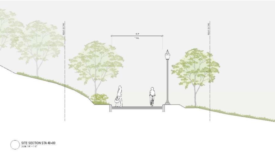
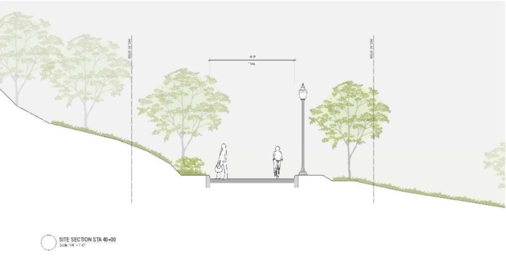
That work includes reconstructing the sidewalks, repaving the street, and adding features to slow down traffic. Two of the biggest traffic-calming features are raised pedestrian crosswalks at two sets of city steps, and landscaping near the entrance to the trail.
In addition, Sylvan Avenue is set to be designated as a Neighborway street, meaning it is a low-traffic street designed for the needs of people on foot, bikes, or other nonmotorized vehicles.
A combination of city and federal funding
The City of Pittsburgh is funding the design phase and street repaving. Construction funding comes from a federal grant with Pennsylvania Department of Transportation oversight, explained Leon Jeziorski of Michael Baker International, the multimodal design firm for the project.
Mr. Panzitta was unclear on the source of federal funding. In a May 9 email, he referred funding questions to Emily Bourne, DOMI communications specialist. Ms. Bourne replied to emailed inquiries that she was coordinating her response with that of Mayor Gainey’s press secretary, Maria Montaño, who had been contacted separately.
Community concerns include parking, safety
During the Q&A portion of the meeting, residents raised concerns about pedestrian safety on Hazelwood Avenue and the limited parking available on Sylvan Avenue.
Pastor Tim Smith, CEO of Center of Life—located at the intersection of Hazelwood and Sylvan avenues—asked if the project will widen the road. He said people park on both sides at that end of the street, which leaves a narrow space for drivers passing in opposite directions. Mr. Jeziorski responded that the project would not address parking issues, and the east side of the street (across from the Center of Life) is currently a “no parking” zone.
A Sylvan Avenue resident who did not give her name said enforcing the “no parking” zone would prevent residents from parking near their homes.
Roy Simms, who said he’d lived on Sylvan Avenue for more than 50 years, asked if the city steps would be repaired as part of the project. Mr. Panzitta answered that the steps are also outside the project’s scope.
Why here, why now?
Several attendees wanted to know more about why this project was identified as a priority now. Despite being touted as a safe multimodal connection, it does not address issues with the steps, the decrepit retaining wall and railing near the future trail entrance (the project will use landscaping to block off the railing rather than fix it, according to Mr. Jeziorski), or dangerous conditions at either end of Sylvan Avenue.
“If you’re looking to increase bike accessibility in a safe way, there’s a lot of already-existing safety issues with Greenfield Avenue,” said Eric Russell, a Greenfield resident and daily bike commuter. “Especially if you’re dumping people onto Greenfield Avenue from Hazelwood.”
Catherine Adams lives on Hazelwood Avenue and said some of her neighbors have been hit by cars. They have been meeting with DOMI and District 5 Councilman Corey O’Connor about speeding and safety issues on Hazelwood Avenue for the past two years.
Mr. Panzitta said the trail is included in the Greater Hazelwood Neighborhood Plan. Page 96 lists “creat[ing] a bicycle route up the hill from and parallel to Second Avenue” as a way to “address gaps in multi-modal network throughout the neighborhood.”
Mr. Jeziorski defended the project, asserting that improved accessibility to this corridor will draw more residents and businesses to the neighborhood. The increased activity should help Hazelwood get grant funding to replace the steps. “So this is a building block that can help with other improvements in the future,” he said.
Bill 1366, first presented at City Council’s April 6 meeting, would award $396,223.31 to Michael Baker International for work on the hotly contested Mon-Oakland Connector (MOC). The MOC, a new road through Schenley Park and two adjacent neighborhoods, is designed to accommodate privately operated shuttles between the Hazelwood Green (HG) development and the Oakland universities where HG’s desired tenants work and learn.
Bill 1366 retains wording from previous versions that states the MOC will “support green infrastructure,” which is false on two counts. First, asphalt surfaces like parking lots and roads add runoff that contributes to flooding in The Run. The proposed shuttle road adds at least 0.80 acres (34,850 square feet) of paving to Junction Hollow. Although PWSA representatives tout a projected reduction in flooding when comparing the “current state” (doing nothing) to their model, the road’s true impact on flooding cannot be measured without an MOC-free project model. Second, the PWSA stormwater project has removed green infrastructure from its design since the original bill was written in 2018.
Bill 1366 also asserts that the MOC will “ensure safe travel” and “protect local neighborhoods” even though the MOC forces cyclists to share space with motorized vehicles in Schenley Park and commandeers streets in The Run neighborhood. Of concern to all affected communities, linear transportation projects like the MOC tend to gentrify surrounding neighborhoods.
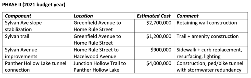
Less than five months ago, City Council unanimously passed a budget amendment that shifted $4.15 million away from the resident-opposed project. $1.2 million of that money was allocated to creating a Sylvan Ave. trail for cyclists and pedestrians, as well as Hazelwood Complete Streets.
Residents of Hazelwood and The Run prioritized neighborhood repairs to fund; a Sylvan Ave. trail did not make the list. $1.2 million would not even cover key projects like safe street crossings in Hazelwood’s business district and an Irvine St./Second Ave. sidewalk upgrade to ADA standards. Yet City Council is considering a bill that would use one third of the MOC funds “reallocated” to Hazelwood on consulting/engineering work already planned for the phase 2/Sylvan Ave. stretch of the MOC. The MOC also has in its coffers an unknown portion of $14.5 million from the 2018 and 2019 budgets.
At the April 14 City Council Standing Meeting, Councilman O’Connor said of Bill 1366, “The title of it, I don’t like and I don’t think the neighborhood likes, but this is part of an extended agreement with Michael Baker, who’s the lead engineer with PWSA as well, so there’s a stormwater piece that is supported.”
He asked Department of Mobility and Infrastructure Director Karina Ricks to “confirm that the money goes to the geotech on Sylvan to make sure it’s stable and the second piece if you can just explain briefly the stormwater, ’cause I know we’re working with PWSA on that.”
Ricks replied, “This supplement is to complete additional geotechnical evaluation of Sylvan; it’s a complex hillside and requires—has been closed for 30 years at this point, so we’re needing to do additional exploration to make sure that that is stable and that we’re able to reopen that for the community plan as the Sylvan Connector and then the other piece of this is to complete work on an associate permit for the stormwater implementation that PWSA is leading.”
Bill 1366 plainly states that it funds the MOC, and all work identified at the April 14 meeting is needed to accommodate the MOC. What’s more, it leaves less than $1 million to fix unsafe infrastructure throughout Hazelwood.
The bill is listed as “affirmatively recommended” on the City of Pittsburgh Legistar website, but has not yet been put to a vote. Residents are encouraging Councilman O’Connor to oppose Bill 1366 and continue working with City Council to fund community-identified needs instead of the MOC, which benefits the HG development at the expense of its neighbors.
Update: According to Councilman O’Connor’s chief of staff Curt Conrad, the funds for Bill 1366 “are not coming out of Hazelwood funds the councilman allocated in the most recent budget. The $1.2 million is still preserved for trail improvements along Sylvan. The funds for Michael Baker are coming from 2019 PayGO and Bond funds” as shown in the table he provided below.
Budget Year
Source
Previous Encumbrance
Current Encumbrance
Total Encumbrance
2018
PayGo
$1,380,000.00
–
$1,380,000.00
2019
PayGo
$255,681.50
$276,663.50
$532,345.00
2019
Bond
–
$119,559.81
$119,559.81
TOTAL
$1,635,681.50
$396,223.31
$2,031,904.81
Two interesting takeaways from this information:
It appears the $397K comes from the $14.5 million for the MOC in the 2018 and 2019 budgets.
The entire $1.2 million from the reallocated 2021 MOC funds is going to “trail improvements along Sylvan” rather than repairs to existing sidewalks in Hazelwood.

Recent Comments