
Proposed shuttle expansion route threatens homes
Developers of the controversial Mon-Oakland Connector (MOC) aren’t deterred by years of setbacks—including widespread community opposition and City Council passing a 2021 budget amendment that shifts funds away from building the new shuttle road through two Pittsburgh neighborhoods and Schenley Park. If anything, plans presented by the Department of Mobility and Infrastructure (DOMI) and Almono Partners at their last public meeting show a stronger resolve to eliminate all obstacles in the MOC’s path.
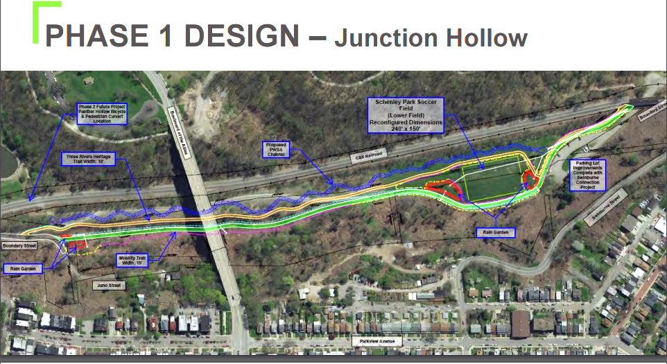
Slide 11 maps the proposed phase 1 MOC route, which ends abruptly as it enters The Run from Schenley Park. Residents were left in the dark about the path of shuttles through their small neighborhood.
Although this meeting marked the first time an Almono Partners representative was on hand to answer questions about the shuttle service they plan to run on the road, they did not show The Run in their presentation, either (see slide 37).
The slide refers to “trails” (plural) and “public streets” with no indication of which streets in The Run will be used.
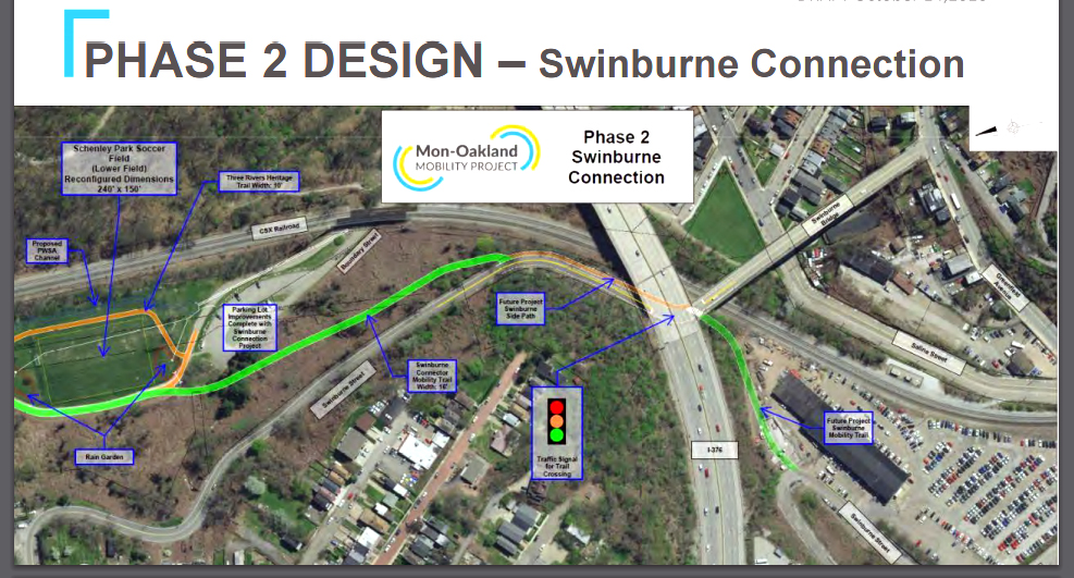
The “Swinburne connector” (slide 22) climbs a landslide-prone hillside and merges with Swinburne Street for access to Swinburne Bridge. An FAQ on DOMI’s website says this additional road would “have a path width of 16 feet with 2-foot buffers on each side.” Longtime followers of the MOC debacle and Run residents find this phase 2 plan equally troubling for several reasons.
For context, we revisit a January 2018 public meeting DOMI organized to “share the potential alternative routes” for the MOC. Run residents had no trust after learning of the plan from a 2015 Pittsburgh Post-Gazette article touting an already-submitted grant application that turned out to be fraudulent. DOMI, created in 2017, claimed they were pushing the restart button on the MOC concept and seeking input from affected communities.
Michael Baker Corporation presented six routes at the meeting, including five community suggestions that left Schenley Park undisturbed. Attendees reported that the exercise seemed designed to herd them toward a conclusion that only the Schenley Park route could work. Alternatives included Swinburne Street.
DOMI director Karina Ricks later expressed a preference for the Swinburne route, but said it was not feasible because of landslides. Landslides have plagued Swinburne Street for decades; one in the 1980s caused damage in Junction Hollow that led the city to close Boundary Street to motorized vehicles. This section of Boundary Street eventually became a popular bike and pedestrian trail through Schenley Park that forms a critical link in the only car-free path between Oakland and downtown.
Given the ongoing landslides, MOC critics questioned Ricks when subsequent designs showed the inevitable Schenley Park shuttle route running along the hill beneath Swinburne Street. How could Swinburne be deemed unsuitable for small shuttles yet frequently accommodate cars, trucks, UPMC shuttles, emergency vehicles, and school buses? And since Swinburne must be stabilized to prevent a collapse onto the proposed road, why not make Swinburne the route instead of spending millions of additional taxpayer dollars to build a new road?
Ricks responded via email, “The mobility path is to be an exclusive pathway suitable for both light shuttles and other e-powered vehicles such as e-bikes and, when categorized, e-scooters and other such vehicles as may evolve over time. There is insufficient width on Swineburn to provided this dedicated path. The street cannot be widened due to the fragile soil conditions.” (emphasis added)
Swinburne Street is 19.8 feet wide on average at its narrowest point. This is significantly wider than the proposed road, which forces cyclists into close contact with shuttles. But the width is still insufficient to accommodate both existing traffic and a new “exclusive pathway” that is “16 feet with 2-foot buffers on each side.” Whatever happened to the fragile soil conditions that prevented Swinburne Street from being widened?
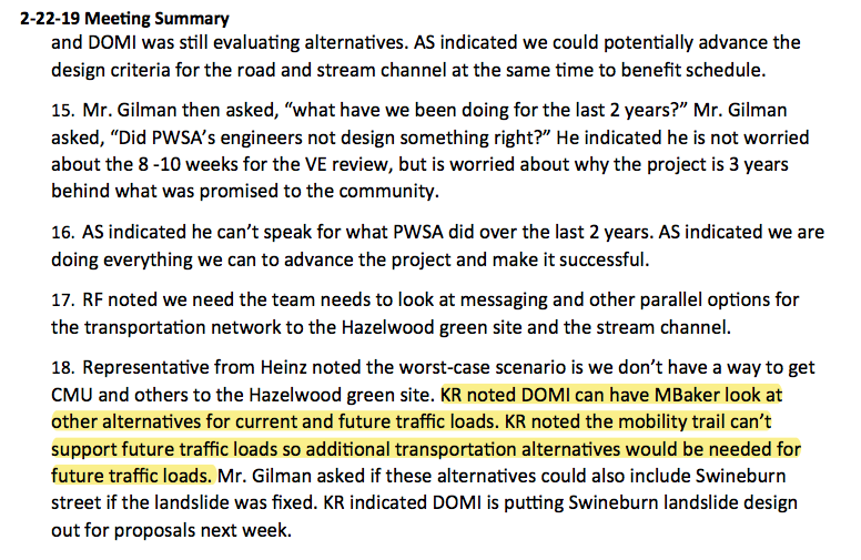
According to minutes from a February 2019 meeting in Mayor Bill Peduto’s office, Ricks “noted the mobility trail can’t support future traffic loads so additional transportation alternatives would be needed for future traffic loads.” DOMI first proposed widening Swinburne Bridge to accommodate a dedicated lane for MOC shuttles in February 2018, presenting an option that featured a vehicle elevator from Four Mile Run Park below. Since then, serious consequences of the Swinburne route have come into view.
Owners of houses near Swinburne Bridge received letters referencing eminent domain.
In August 2020, several Run residents who live near Swinburne Bridge received letters from DOMI implying they may lose their homes and businesses through eminent domain. The bridge has been neglected over many years and needs repair, so residents are required to allow surveyors on their property. Although repairs could be completed with no need to acquire properties, replacing Swinburne Bridge allows DOMI to widen it for the purpose of accommodating a dedicated MOC shuttle lane.
Ricks addressed resident concerns by stating, “It is a letter written by a lawyer and, unfortunately, they do reference the right of eminent domain. The City has absolutely no intention to take properties [as part of the bridge construction]. There is a possibility there might be some slivers that will be needed to create new footings for the bridge.”
Within a week of property owners receiving the letters, an AWK Consulting Engineers team arrived in The Run. One affected property owner noticed a surveyor working in Four Mile Run Field (The Run’s only community green space). Asked why he was so far from the bridge, the AWK employee said it was because they might need to widen the bridge.
Residents throughout The Run face harm from still more asphalt surfaces and permanent tree canopy loss upstream from their homes. Phase 1 of the MOC has already compromised the Pittsburgh Water and Sewer Authority’s stormwater project in the area because accommodating the shuttle road is a design requirement. The stormwater project enjoys nearly universal public support because it was sold as a solution to The Run’s chronic flooding problem. But building the half-mile road through Schenley Park would generate about 295,000 gallons of additional runoff.
DOMI calls the MOC a “mobility trail” to avoid admitting it is a road—and if the MOC can be called a trail, its shuttles can run on any trail. An additional leg of the “Swinburne Connection” extends into the UPMC shuttle lot toward Second Avenue, which also happens to link to the Eliza Furnace Trail, another crucial part of Pittsburgh’s car-free network.
The MOC is a reiteration of an old idea. And it continues to shamble forward, powered by $14 million from previous budget years. The “Swinburne Connection” reveals MOC planners deceiving residents yet again, feinting away from an “alternative” route they planned to use in addition to rather than instead of Schenley Park. Communities should not be asked—let alone forced—to sacrifice themselves for the sake of a development project that serves private interests.

Recent Comments